|
Western Armenia
Treaty of Sevres
SECTION VI..
ARMENIA.
ARTICLE 88.
Turkey, in accordance with the action already
taken by the Allied Powers, hereby recognises Armenia as a free and
independent State.
ARTICLE 89.
Turkey and Armenia as well as the other High
Contracting Parties agree to submit to the arbitration of the
President of the United States of America the question of the
frontier to be fixed between Turkey and Armenia in the Vilayets of
Erzerum, Trebizond, Van and Bitlis, and to accept his decision
thereupon, as well as any stipulations he may prescribe as to access
for Armenia to the sea, and as to the demilitarisation of any
portion of Turkish territory adjacent to the said frontier.
ARTICLE 90.
In the event of the determination of the frontier
under Article 89 involving the transfer of the whole or any part of
the territory of the said Vilayets to Armenia, Turkey hereby
renounces as from the date of such decision all rights and title
over the territory so transferred. Ihe provisions of the present
Treaty applicable to territory detached from Turkey shall thereupon
become applicable to the said territory
The proportion and nature of the financial
obligations of Turkey which Armenia will have to assume, or of the
rights which will pass to her, on account of the transfer of the
said territory will be determined in accordance with Articles 241 to
244. Part VIII (Financial Clauses) of the present Treaty.
Subsequent agreements will if necessary, decide
all questions which are not decided by the present Treaty and which
may arise in consequence of the transfer of the said territory,
ARTICLE 91.
In the event of any portion of the territory
referred to in Article 89 heing transferred to Armenia, a Boundary
Commissionm whose composition will be determined subsequetly, will
be constituted within three months from the delivery of the decision
referred to in the said Article to trace on the spot the frontier
between Armenia and Turkey as established by such decision.
ARTICLE 92.
The frontiers between Armenia and Azerbaijan and
Georgia respectively will be determined by direct agreement between
the States concerned.
If in either case the States concerned have
failed to determine the frontier by agreement at the date of the
decision referred to in Article 89, the frontier line in question
will be determined by the Principal Allied Powers, who will also
provide for its being traced on the spot.
ARTICLE 93
Armenia accepts and agrees to embody in a Treaty
with the Principal Allied Powers such provisions as may be deemed
necessary by these Powers to protect the interests of inhabitants of
that State who differ from the majority of the population in race,
language, or religion.
Armenia further accepts and agrees to embody in a
Treaty with the Principal Allied Powers such provisions as these
Powers may deem necessary to protect freedom of transit and
equitable treatment for the commerce of other nations.
President Wilsons acceptance letter for drawing
the frontier.
PRESIDENT WILSON
TO THE PRESIDENT OF THE SUPREME COUNCIL OF THE
ALLIED POWERS
MR. PRESIDENT:
By action of the Supreme Council taken on April
26th of this year an invitation was tendered to me to arbitrate the
question of the boundaries between Turkey and the new state of
Armenia. Representatives of the powers signatory on August 10th of
this year to the Treaty of Sevres have acquiesced in conferring this
honor upon me and have signified their intention of accepting the
frontiers which are to be determined by my decision, as well as any
stipulation which I may prescribe as to access for Armenia to the
sea and any arrangement for the demilitarization of Turkish
territory lying along the frontier thus established. According to
the terms of the arbitral reference set forth in part III, Section
6, Article 89, of the Treaty of Sevres, the scope of the arbitral
competence assigned to me is clearly limited to the determination of
the frontiers of Turkey and Armenia in the Vilayets of Erzernm,
Trebizond, Van and Bitlis. With full consciousness of the
responsibility placed upon me by your request, I have approached
this difficult task with eagerness to serve the best interests of
the Armenian people as well as the remaining in habitants, of
whatever race or religious belief they may be, in this stricken
country, attempting to exercise also the strictest possible justice
toward the populations, whether Turkish, Kurdish, Greek or Armenian,
living in the adjacent areas.
In approaching this problem it was obvious that
the existing ethnic and religions distribution of the population in
the four vilayets could not, as in other parts of the world, be
regarded as the guiding element of the decision. The ethnic
consideration, in the case of a population originally so complexly
intermingled, is further beclouded by the terrible results of the
massacres and deportations of the Armenians and Greeks, and by the
dreadful losses also suffered by the moslem inhabitants through
refugee movements and the scourge of typhus and other diseases. The
limitation of the arbitral assignment to the four vilayets named in
Article 89 of the Treaty made it seem a duty and an obligation that
as large an area within these vilayets be granted to the Armenian
state as could be done, while meeting the basic requirements of an
adequate natural frontier and of geographic and economic unity for
the new state. It was essential to keep in mind that the new state
of Armenia, including as it will a large section of the former
Armenian provinces of Transcaucasian Russia, will at the outset have
a population about equally divided between Moslem and Christian
elements and of diverse racial and tribal relationship. The
citizenship of the Armenian Republic will, by the tests of language
and religion, be composed of Turks, Kurds, Greeks, Kizilbashis,
Lazes and others, as well as Armenians. The conflicting territorial
desires of Armenians, Turks, Kurds and Greeks along the boundaries
assigned to my arbitral decision could not always be harmonized. In
such cases it was my belief that consideration of healthy economic
life for the future state of Armenia should be decisive. where,
however, the requirements of a correct geographic boundary permitted,
all mountain and valley districts along the border which were
predomi. nantly Kurdish or Turkish have been left to Turkey rather
than assigned to Armenia, unless trade relations with definite
market towns threw them necessarily into the Armenian state.
Wherever informaion upon tribal relations and seasonal migrations
was obtainable, the attempt was made to respect the integrity of
tribal groupings and nomad pastoral move ments.
From the Persian border southwest of the town of
Kotur the boundary line of Armenia is determined by a rugged natural
barrier of great height, extending south of Lake Van and lying
southwest of the Armenian cities of flitlis and Mush. This boundary
line leaves as a part of the Turkish state the entire Saudjak of
Hakkiari, or about one-half of the Vilayet of Van, and almost the
entire Sandjak of Sairt. The sound physiographic reason which seemed
to justify this decision was further strengthened by the
ethnographic consideration that Hakkiari and Said are predominently
Kurdish in population and economic relations. It did not seem to the
best interest of the Armenian state to include in it the upper
valley of the Great Zab River, largely Kurdish and Nestorian
Christian in population and an essential element of the great Tigris
river irrigation system of Turkish Kurdistan and Mesopotamia. The
control of these headwaters should be kept, wherever possible,
within the domain of the two interested states, Turkey and
Mesopotamia. For these reasons the Armenian claim upon the upper
valley of tile Great Zab could not be satisfied.
The boundary upon the west from Bitlis and Mush
northward to the vicinity of Erzingan lies well within Bitlis and
Erzerum vilayets. It follows a natural geographic barrier, which
furnishes Armenia with per fect security and leaves to the Turkish
state an area which is strongly Kurdish. Armenian villages and
village nuclei in this section, such as Kighi and Temran,
necessarily remain Turkish because of the strong commercial and
church ties which connect them with Kliarput rather (than?) with any
Armenian market and religious centers which lie within ilitlis or
Erzermn vilayets. This decision seemed an unavoidable consequence of
the inclusion of the city and district of Kharput in the Turkish
state as determined by Article 27 11(4) and Article 89 of the Treaty
of Sevrcs.
From the northern border of the Dersim the nature
and the direction of the frontier decision was primarily dependent
upon the vital question of supplying an adequate access to the sea
for the state of Armenia. Upon the correct solution of this problem
depends, in my judgment, the future economic well-being of the
entire population, Turkish, Kurdish, Greek, Armenian, or Yezidi, in
those portions of the vilayets of Erzerum, Bitlis and Van which lie
within the state of Armenia. I was not unmindful of the desire of
the Pontie Greeks, submitted to me in a memorandum similar, no
doubt, in argument and content to that presented to the Su preme
Council last March at its London Conference, that the unity of the
coastal area of the Black sea inhabited by them be preserved and
that arrangement be made for an autonomous administration for the re
gion stretching from Riza to a point west of Sinope. The arbitral
juris diction assigned to me by Article 89 of the Treaty of Sevres
does not in. elude the possibility of decision or recommendation by
me upon the ques tion of their desire for independence, or failing
that, for autonomy. Nor does it include the right to deal with the
littoral of the independent Sandjak of Djanik or of the Vilayet of
Kastamuni into which extends the region of the unity and autonomy
desired by the Pontic Greeks.
Three possible courses lay open to me: to so
delimit the boundary that the whole of Trebizond Vilayet would lie
within Turkey, to grant it in its entirety to Armenia, or to grant a
part of it to Armenia and leave the remainder to Turkey. The
majority of the population of Trebizond Vilayet is incontestably
Moslem and the Armenian element, according to all pre-war estimates,
was undeniably inferior numerically to the Greek portion of the
Christian minority. Against a decision so clearly indicated on
ethnographic grounds weighed heavily the future of Armenia. I could
only regard the question in the light of the needs of a new
political entity, Armenia, with mingled Moslem and Christian
populations, rather than as a question of the future of the
Armenians alone. It has been and is now increasingly my conviction
that the arrangements providing for Armenia's access to the sea must
be such as to offer every possibility for the development of this
state as one capable of reassuming and maintain ing that useful role
in the commerce of the world which its geographic position, athwart
a great historic trade route, assigned to it in the past The
civilization and the happiness of its mingled population will
largely depend upon the building of railways and the increased
accessibility of the hinterland of the three vilayets to European
trade and cultural influ ences.
Eastward from the port of Trebizond along die
coast of Lazistan no adequate harbor facilities are to be found and
the rugged character of the Pontic range separating Lazistan Sandjak
from the Vilayet of Erzerum is such as to isolate the hinterland
from the coast so far as practicable railway construction is
concerned. The existing caravan route from Persia across the plains
of Hayazid and Erzcrum, which passes through the towns of Baiburt
and Gumush-khana and debouches upon the Black Sea at Trebizond, has
behind it a long record of persistent usefulness.
These were the considerations which have forced
me to revert to my original conviction that the town and harbor of
Trebizond must become an integral part of Armenia. Because of the
still greater adaptability of the route of the Karshut valley,
ending at the town of Tireboli, for suc cessful railway construction
and operation I have deemed also essential to include this valley in
Armenia, with enough territory lying west of it to insure its
adequate protection. I am not unaware that the leaders of the
Armenian delegations have expressed their willingness to renounce
claim upon that portion of Trebizond Vilayet lying west of Surmena.
Commendable as is their desire to avoid the assumption of authorhy
over a territory so predominantly Moslem, I am confident that, in ac
quiescing in their eagerness to do justice to the Turks and Greeks
in Trebizond I should be doing an irreparable injury to the future
of the land of Armenia and its entire population, of which they will
be a part.
It was upon such a basis, Mr. President, that the
boundaries were so drawn as to follow mountain ridges west of the
city of Erzingan to the Pontic range and thence to the Black Sea, in
such a way as to include in Armenia the indentation called Zephyr
Bey. The decision to ]eave to Turkey the harbor towns and hinterland
of Kerasun and Ordu in Trebizond Sandjak was dictated by the fact
that the population of this region is strongly Moslem and Turkish
and that these towns are the out lets for the easterumost sections
of the Turkish vilayet of Sivas. The parts of Erzeium and Trebizond
Vilayets which, by reason of this delimitation, remain Turkish
rather than become Armenian comprise approximately 12,120 square
kilometers.
In the matter of demilitarization of Turkish
territory adjacent to the Armenian border as it has been broadly
described above, it seemed both impracticable and unnecessary to
establish a demilitarized zone which would require elaborate
prescriptions and complex agencies for their execution. Fortunately,
Article 177 of the Treaty of Sevres prescribes the disarming of all
existing forts throughout Turkey. Articles 159 and 196-200 provide
in addition agencies entirely adequate to meet all the dangers of
disorder which may arise along the borders, the former by the
requirement that a proportion of the officers of the gendarmerie
shall be supplied by the various Allied or neutral Powers, the
latter by the estab lishment of a Military Inter-Allied Commission
of Control and Organi zation. In these circumstances the only
additional prescriptions which seemed necessary and advisable were
that the Military Inter-Allied Commission of Control and
Organization should, in conformity with the powers bestowed upon it
by Article 200 of the Treaty, select the superior officers of the
gendarmerie to be stationed in the vilayets of Turkey lying
contiguous to the frontiers of Armenia solely from those officers
who will be detailed by the Allied or neutral Powers in accordance
with Article 159 of the Treaty; and that these officers, under the
supervision of the Military Inter-Mijed Commission of Organization
and Control, should be especially charged with the duty of
preventing military preparations directed against the Armenian
frontier.
It is my confident expectation that the Armenian
refugees and their leaders, in the period of their return into the
territory thus assigned to them, will by refraining from any and all
form of reprisals give to the world an example of that high moral
courage which must always be the foundation of national strength.
The world expects of them that they give every encouragement and
help within their power to those Turkish refugees who may desire to
return to their former homes in the districts of Trebizond, Erzerum,
Van and Bitlis remembering that these peoples, too, have suffered
greatly. It is my further expectation that they will offer such
considerate treatment to the Laz and the Greek inhabitants of the
coastal region of the Black Sea, surpassing in the liberality of
their administrative arrangements, if necessary, even the ample
provisions for non-Armenian racial and religious groups embodied in
the Minorities Treaty signed by them upon August 10th of this year,
that these peoples will gladly and willingly work in completest
harmony with the Armenians in laying firmly the foundation of the
new Republic of Armenia.
I have the honor to submit herewith the text of
my decision.
Accept (etc.).
WOODROW WILSON
WASHINGTON, NOVEMBER 22, 1920.
President Wilsons letter defining the border
between Armenia and Turkey.
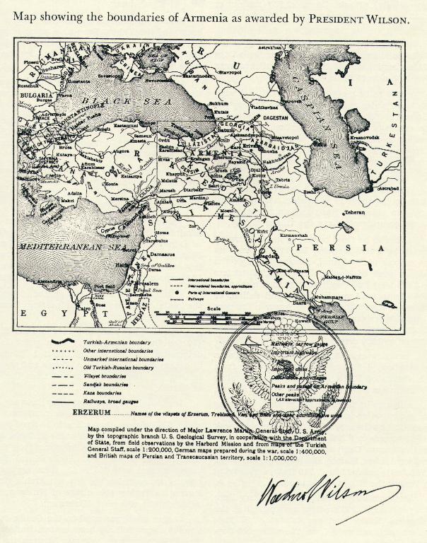
DECISION OF PRESIDENT WILSON
Respecting the Frontier Betteen Turkey and
Armenia, Access for Armenia to the Sea, and the Demilitarization of
Turkish Territory Adjacent to the Armenian Frontier.
WOODROW WILSON, PRESIDENT OF THE UNITED STATES,
TO WHOM IT SHALL CONCERN,
GREETING:
Whereas, on April 26, 1920, the Supreme Council
of the Allied Powers, in conference at San Remo, addressed to the
President of the United States of America an inviation to act as
arbitrator in the question of the boundary be tween Turkey and
Armenia, to be fixed within the four Vilayets of Erzeru:n, Trebizond,
Van, and Bitlis;
And whereas, on May 17, 1920, my acceptance of
this invitation was telegraphed to the American Ambassador in Paris,
to be conveyed to the Powers represented on the Supreme Council;
And whereas, on August 10, 1920, a Treaty of
Peace was signed at Sevres by Plenipotentiary Representatives of the
British Empire, France, Italy and Japan, and of Armenia, Belgium,
Greece, Poland, Portugal, Roumania, and Czecho Slovakia, of the one
part; and of Turkey, of the other part, which Treaty contained,
among other provisions, the following:
"ARTICLE 89. Turkey and Armenia as well as the
other High Contracting Parties agree to submit to the arbitration of
the President of the United States of America the question of the
frontier to be fixed between Turkey and Armenia in the Vilayets of
Erzerum, Trebizond, Van and Bitlis, and to accept his decision
thereupon, as well as any stipulations he may prescribe as to access
for Armenia to the sea, and as to the demilitarization of any
portion of Turkish territory adjacent to the said frontier";
And whereas, on October 18, 1920, the Secretariat
General of the Peace Conference, acting under the instructions of
the Allied Powers, transmitted to me, through the Embassy of the
United States of America in Paris, an authenticated copy of the
above mentioned Treaty, drawing attention to the said Article 89;
Now, therefore, I, Woodrow Wilson, President of
the United States of America, upon whom has thus been conferred the
authority of arbitrator, having examined the question in the light
of the most trustworthy information available, and with a mind to
the highest interests of justice, do hereby declare the following
decision:
I
The frontier between Turkey and Armenia in the
Vilayets of Erzerum, Trebizond, Van, and Bitlis, shall be fixed as
follows:
1. The initial point* shall be chosen on the
ground at the junction of the Turkish-Persian frontier with the
eastern termination of the administrative boundary between the
Sandjaks of Van and Hakkiari, of the Vilayet of Van, as this
administrative boundary appears upon the Bashkala sheet of the
Turkish map, scale 1 :200,000, editions published in the Turkish
financial years 1330 and 1331 (1914-15). From this initial point the
boundary shall extend southwest- ward to the western peak of
Merkezer Dagh, situated about 6 kilometers west ward from point 3350
(10,990 feet), about 2 kilometers southeastward from the village of
Yokary Ahvalan, and approximately 76 kilometers southeastward from
the city of Van.
*It is my understanding that this initial point
will lie upon the former Turkish-Persian frontier referred to in the
Article 27 II (4) of the Treaty of Sevres; but 40 miles of the said
frontier, within which the initial point of the Armenian frontier is
included, were left undemarcated by the Turko-Persian Frontier
Commission in 1914. The initial point contemplated lies about 1
kilometer southward from the village of Kara Hissa and approximately
25 kilo meters southwestward from the village of Kotur, and may be
fixed on the ground as near this location as the Boundary Commission
shall determine, provided it lies at the junction of the
Van-Hakkiari Sandjak boundary with the frontier of Persia
the sandjak boundary specified above, then the
administrative boundary between the Kazas of Mamuret-ul-Hamid and
Elback, then the same sandjak boundary specified above, all modified,
where necessary, to follow the main water-parting between the Zap Su
(Great Zab River) and the Khoshab Su, and dividing equably the
summits of the passes Krdes Gedik and Chokh Gedik;
then northwestward about 28 kilometers to Klesiry
Dagh,
a line to be fixed on the ground, following the
main water-partings between the Khoshab Su and the streams flowing
into the Shatak Su, and traversing the pass south of the village of
Yokary Ahvalan, and passing through Shkolans Dagh (3100 meters or
10,170 feet) and the Belereshuk pass;
thence southwestward to the junction of an
unnamed stream with the Shatak Su at a point about 10 kilometers
southward from the village of Shatak,
a line to be fixed on the ground, following the
main water-partings, and passing through Koh Kiran Daghlar, Sari
Dagh (3150 meters or 10,335 feet), Kevmetala Tepe (3,500 meters or
11,480 feet, point 3,540 (11,615 feet), in such a way as to leave to
Armenia the village of Eyreti, and to Turkey the village of Araz,
and to cross the Shatak Su at least 2 kilometers southward from the
village of Dir Mouem Kilisa;
thence westward to the point where the Bitlis-Van
Vilayet boundary reaches the Moks Su from the west, situated about
18 kilometers southward from the village of Moks,
a line to he fixed on the ground, following the
main water-partings, leaving to Armenia the villages of Kachet,
Sinpass, and Ozim, passing through Kanisor Tepe (3,245 meters or
10,645 feet), an unnamed peak about 3 kilometers southward from
Arnus Dagh (3,550 meters or 11,645 feet), crossing an unnamed stream
about 2 kilometers southward from the village of Sinpass, passing
through point 3,000 (9,840 feet), following the boundary between the
Vilayets of Van and Bitlis for about 3 kilometers southwestward from
this point and continuing southwestward on the same ridge to an
unnamed peak about 2 kilometers eastward from Moks Su, and then
descending to this stream;
thence northward to an unnamed peak on the
boundary between the Vilayets of Van and Bitlis about 3 kilometers
westward from the pass at Mata Gedik,
the administrative boundary between the Vilayets
of Van and Bitlis, modified south of Vankin Dagh (3,200 meters or
10,500 feet) to follow the main water-parting;
thence westward to the peak Meidan Chenidiani,
situated on the boundary between the Sandjaks of Bitlis and Sairt
about 29 kilometers southeastward from the city of Bitlis,
a line to be fixed on the ground, following the
main water-partings, passing through Veberhan Dagh (3410 meters or
10,200 feet), crossing the Kesan Dere about 2 kilometers southward
from the village of Khoros, leaving to Turkey the villages of Semhaj
and Nevaleyn as well as the bridge or ford on the trail between them,
and leaving to Armenia the village of Chopans and the trail leading
to it from the northeast;
thence westward to the Guzel Dere Su at a point
about 23 kilometers southward from the city of Bitlis and about 2
kilometers southward from Nuri Ser peak (2450 meters or 7,050 feet),
the administrative boundary between the Sandjaks
of Bitlis and Sairt, and then, a line to he fixed on the ground,
following the main water-partings, and passing through points 2,750
and 2,700 of Kur Dagh (9,020 and 8,860 feet respectively), Biluki
Dagh (2,230 meters or 7,315 feet), and Sihaser Tepe (2,250 meters or
7,380 feet);
thence westward to the junction of the Bitlis Su
and the unnamed stream near the village of Deshtumi, about 30
kilometers southwestward from the city of Bitlis,
a line to be fixed on the ground, following the
main water-partings, leaving to Turkey the villages of Lered and
Daruni, and to Armenia the village of Enbu and all portions of the
trail leading northeastward to the Bitlis Su from Mergelu peak
(1,850 meters or 6,070 feet), and passing through Mergelu Tepe and
Shikh Tabur ridge;
thence westward to the Zuk (Gharzan) Su at the
point about 11 kilometers northeastward from the village of Hazo and
approximately 1 kilometer upstream from the village of Zily,
a line to be fixed on the ground, following the
main water-partings, leaving to Armenia the village of Deshtumi,
passing through the eastern peak of Kalmen Dagh (2.710 meters or
8,890 feet) and continuing in such a manner as to leave to Armenia
the upland dolina, or basin of interior drainage, to traverse
the pass about 3 kilometers westward from the village of Avesipy,
passing through Shelash Dagh (1,944 meters or 6,380 feet);
thence westward to the Sassun Dere at a point
about 4 kilometers south. westward from the village of Kabil Jeviz
and approximately 47 kilometers southward from the city of Mush,
a line to be fixed on the ground, following the
main water-partings through Cheyardash peak (2,001 meters or 6,565
feet), Keupeka peak (1,931 meters or 6,335 feet), an unnamed peak on
the Sassun Dagh about 4 kilometers south westward from Malato Dagh
(2,967 meters or 9,735 feet), point 2,229 (7,310 feet), and leaving
to Turkey the village of Gundenu;
thence northwestward to the Talury Dere at a
point about 2 kilometers upstream from the village of Kasser and
approximately 37 kilometers north. eastward from the village of
Seylevan (Farkin),
a line to be fixed on the ground, following the
main water-partings and passing through an unnamed peak about 2
kilometers eastward from the village of Seyluk, and through point
2,073 (6,800 feet), leaving to Armenia the village of Heyshtirem;
thence northwestward to the western tributary of
the Talury Dere at a point about 2 kilometers eastward from the
village of Helin and approximately 42 kilometers southwestward from
the city of Mush,
a line to be fixed on the ground, following the
main water-partings, and passing through point 2,251 (7,385 feet);
thence northwestward to the junction of the Kulp
Boghazy (Kulp Sa) and Askar Dere, approximate]y 42 kilometers
southwestward front city of Mush,
a line to be fixed on the ground, following the
main water-partings ]eaving to Turkey the village of Helin and to
Armenia the village of Kehirvanik;
thence northwestward to a point on the
administrative boundary between the Sandjaks of Gendj and Mush
northeast of Mir Ismail Dagh, and situated about 5 kilometers
westward from the village of Pelekoz, and approximately 19
kilometers southward from the village of Ardushin,
a line to he fixed on the ground, following the
main water-partings, and passing through the Komiss Dagh;
thence northwestward to the Frat Nehri (Murad Su,
or Euphrates) at a point to be determined on the ground about 1
kilometer upstream from the village of Dorne and approximately 56
kilometers westward from the city of Mush,
the administrative boundary between the Sandjaks
of Gendj and Mush northward for about 2 kilometers, then a line to
be fixed on the ground, following the main water-partings westward
to an unnamed peak approximately 6 kilometers east of Chutela (Akche
Kara) Dagh (2,940 meters or 9,645 feet), then northward passing
through Hadije Tepe on Arshik Dagh, leaving to Turkey the village of
Kulay and to Armenia the village of Kluhuran;
thence northwestward to the Gunik Su at a point
about midway between two trails crossing this river about half way
between the villages of Elmaly and Chenajki, and approximately 26
kilometers northeastward from the village of Cholik (Chevelik),
a line to be fixed on the ground, following the
main water-partings, passing through an unnamed peak about 2
kilometers westward from the village of Shanghar, along Solkhan
Dagh, and through point 2,200 (7,220 feet), leaving to Turkey the
villages of Shanghar and Chenajky, and to Armenia the villages of
Kumistan, Lichinak, and Elmaly;
thence northwestward to the boundary between the
Vilayets of Erzerum and Bitlis at an unnamed peak near where a
straight line between the villages of Erchek and Agha Keui would
intersect said vilayet boundary,
a line to be fixed on the ground, following the
main water-partings, passing through point 2,050 (6,725 feet);
thence northward to an unnamed peak on said
vilayet boundary about 8 kilometers northwestward from Kartalik Tepe
on the Choris Dagh,
the administrative boundary between the vilayets
of Erzerum and Bitlis;
thence westward to the Buyuk Su (Kighi Su) at a
point about 2 kilometers upstream from the junction of the Ghabzu
Dere with it, and approximately 11 kilometers northwestward from the
village of Kighi,
a line to be fixed on the ground, following the
main water-partings of the Sheitan Daghlar, passing through points
2,610 (8565 feet), Sheitan Dagh (2,906 meters or 9,535 feet),
Hakstun Dagh, and leaving to Armenia the village of Dinek and the
ford or bridge southwest of this village;
thence westward to the Dar Boghaz (Kuttu Dere) at
a point about 3 kilo meters southward from the village of Chardaklar
(Palumor),
a line to be fixed on the ground, following the
main water-partings, leaving to Armenia the villages of Shorakh and
Ferhadin, passing through Ghabarti Dagh (2,550 meters or 8,365 feet),
Sian Dagh (2,750 meters or 9,020 feet), the 2450 meter pass on the
Palumor-Kighi trail near Mustapha Bey Konaghy, Feziria Tepe (2,530
meters or 8,300 feet), point 2,244 (7,360 feet), and point 2,035
(6,675 feet)
thence westward to the point common to the
boundaries of the Sandjaks of Erzingan and Erzerum and the Vilayet
of Mamuret-ul-Aziz, situated at a sharp angle in the vilayet
boundary, approximately 24 kilometers westward from the village of
Palumor and 32 kilometers southeastward from the city of Erzingan,
a line to be fixed on the ground, following the
main water-partings, and passing northwestward through an unnamed
peak about 2 kilometers southwestward from Palumor, through Silos (Kersinod)
Dagh (2,405 meters or 7,890 feet) to an unnamed peak on the southern
boundary of the Sandjak of Erzingan, about 8 kilometers
southwestward from the Palumor-Erzingan pass, then turning
southwestward along said Sandjak boundary for nearly 13 kilometers,
passing through Karaja Kaleh (3,100 meters or 10470 feet)
thence westward to an unnamed peak on the
boundary between the Vilayets of Erzerum and Mamuret-ul-Aziz about 3
kilometers northeastward from the pass on the trail across the
Monzur Silsilesi between Kennakh on the Euphrates and Pelur in the
Dersim, the peak being approximately 40 kilometers southwestward
from the city of Erzingan,
the administrative boundary between the vilayets
of Erzerum and Mamuret ul-Aziz; modified*, in case of a majority of
the voting members of the Boundary Commission deem it wise, to
follow the main water-parting along the ridge between an unnamed
peak about 2 kilometers southwest of Merjan Daghlar (3,449 meters or
11,315 feet) and Katar Tepe (3,300 meters or 10,825 feet);
*At the locality named. the vilayet boundary (according
to Khozat-Dersim sheet of the Turkish General Staff map, scale
1:200,000) descends the northern slope of the Monzur-Silsilesi for
about 7 kilometers. The junction of the boundary between the Kazas
of Erzingan and Kemakh in Erzingan Sandjak of Erzernm
thence northward to the Frat Nehri (Kara Su, or
Euphrates) at a point to be determined on the ground about 6
kilometers eastward from the village or Kemagh and approximately 35
kilometers southwestward from the city of Erzingan,
a line to be fixed on the ground, following the
main water-partings, leaving to Turkey the trail from Pelur in the
Dersim to Kemakh on the Euphrates, and to Armenia the village of
Koja Arbler;
thence, northward to the boundary between the
vilayets of Erzerum and Trebizond at a point to be determined about
1 kilometer west of peak 2,930 (2,630 or 8,625 feet) and about 4
kilometers southward from the village of Metkut, or approximately 39
kilometers northwestward from the city of Erzingan,
a line to be fixed on the gronnd, following the
main water-partings, leaving to Turkey the villages of Chalghy Yady,
Toms, and Alamlik, and to Armenia the village of Erkghan and the
road and col south of the village of Metkut, passing through Utch
Kardash Tepe, Kelek Kiran (Tekke Tash, 2,800 meters or 9,185 feet),
Kehnam Dagh (or Kara Dagh, 3,030 meters or 9,940 feet), dividing
equably between Armenia and Turkey the summit of the pass about 2
kilometers westward from the village of Zazker and, similarly, the
summit of the pass of Kral Kham Boghazy near the village of
Chardakli, passing through point 2760 on Kara Dagh (9,055 feet),
point 2,740 (8,990 feet), and a point to be determined on the ground,
situated near the Iky Sivry stream less than 2 kilometers westward
from the Chimen Dagh pass, and located in such a manner as to leave
to Turkey the junction of the two roads leading westward to the
villages of Kuchi Keui and Kara Yayrak, and to Armenia the junction
of two other roads leading to the villages of Metkut and Kirmana;
the Boundary Commission shall determine in the field the most
equable disposition of the highway between points 2,760 and 2,740;
Vilayet with the boundary of Dersim Sandjak of
Mamuret-ul-Aziz Vilayet lies within 14 kilometers of the Euphrates
River. This leaves to Turkey a military bridgehead north of an
11,000 foot mountain range and only 20 kilometers south of the city
of Erzingan. I am not empowered to change the administrative
boundary at this point, and these 40 square kilometers of territory
lie outside the four vilayets specifid in Article 89 of the Treaty
of Sevres.
However, I venture to call the attention of the Boundary Commission
to the desirability of consulting the local inhabitants with a view
to possible modification of the vilayet boundary at this point.
thence northwestward to the Kelkit Chai (Kelkit
Irmak) at the point where the boundary between the Vilayets of
Trebizond and Sivas reaches it from the south,
the administrative boundary between the Vilayets
of Trebizond and Erzerum, and then the administrative boundary
between the Vilayets of Trebizond and Sivas;
thence northward to an unnamed peak on the
boundary between the Vilayets of Trebizond and Sivas about 4
kilometers southwestward from Borgha Paya (2,995 meters or 9,825
feet) the latter being situated approximately 38 kilometers
southwestward from the city of Gumush-Khana,
a line to be fixed on the ground, following the
main water-partings, leaving to Armenia the villages of Halkit,
Sinanli, Kiliktin, and Kirtanos; and to Turkey the villages of Kar
Kishla, Sadik, Kara Kia, and Ara, crossing the pass between the
western tributaries of the Shiran Chai and the eastern headwaters of
the Barsak Dere (Kara Chai) about 43 kilometers eastward from the
city of Karahissar Sharki (Shebin Karahissar);
thence northeastward, northward, and westward to
an unnamed peak on the boundary between the Vilayets of Trebizond
and Sivas situated about 7 kilometers northwestward from Yerchi Tepe
(2,690 meters or 8,825 feet) and approximately 47 kilometers south
southeastward from the city of Kerasun,
the administrative boundary between the Vilayets
of Trebizond and Sivas;
thence northward, from the point last mentioned,
on the crest of the Pontic Range, to the Black Sea, at a point to be
determined on the seacoast about 1 kilometer westward from the
village of Keshab, and approximately 9 kilometers eastward from the
city of Kerasun,
a line to be fixed on the ground, following the
main water-partings, leaving to Turkey the fields, pastures,
forests, and villages within the drainage basin of the Komit Dere
(Ak Su) and its tributaries; and to Armenia the fields, pastures,
forest, and villages within the drainage basins of the Yaghaj Dere
(Espiya Dere) and the Venazit Dere (Keshab Dere) and their
tributaries, and drawn in such a manner as to utilize the boundary
between the Kazas of Tripoli (Tireboli) and Kerasun in the 7
kilometers just south of Kara Tepe (1,696 meters or 5,565 feet), and
to provide the most convenient relationships between the new
frontier and the trails along the ridges, as these relationships may
be determined by the Boundary Commission in the field after
consultation with the local inhabitants.
2. In case of any discrepancies between the text
of this Decision and the maps on the scales of 1:1,000,000 and
1:200,000 annexed, the text will be final.
The limits of the four vilayets specified in
Article 89 of the Treaty of Sevres are taken as of October 29, 1914.
The frontier, as described above, is drawn in red
on an authenticated map on the scale of 1:1,000,000 which is annexed
to the present Frontier Decision. The geographical names here
mentioned appear upon the maps accompanying this text.
The chief authorities used for the names of
Geographical features, and of elevations of mountains, and the
location of vilayet, sandjak, and kaza houndaries, are the Turkish
General Staff map, scale 1:200,000, and, in part, the British map,
scale 1:1,000,000.
The maps on the scale of 1:200,000 are
recommended to the Boundary Commission, provided in Article 91, for
their use in tracing on tbe spot the portion of the frontiers of
Armenia established by this Decision.
II
The frontier described above, by assigning the
harbor of Trebizond and the valley of Karshut Su to Armenia,
precludes the necessity of further provision for access for Armenia
to the sea.
III
In addition to the general provisions for the
limitation of armaments, embodied in the Military, Naval and Air
Clauses, Part V of the Treaty of Sevres, the demilitarization of
Turkish territory adjacent to the frontier of Armenia as above
established shall be effected as follows:
The Military Inter-Allied Commission of Control
and Organization provided for in Articles 196-200 of the Treaty of
Sevres shall appoint the superior officers of the gendarmerie
stationed in those vilayets of Turkey lying contiguous to the
frontiers of the state of Armenia exclusively from the officers to
be supplied by the various Allied or neutral Powers according to
Article 139 of the said Treaty.
These officers shall, in addition to their other
duties, be especially charged with the task of observing and
reporting to the Military Inter-Allied Commission of Control and
Organization upon any tendencies within these Turkish vilayets
toward military aggression against the Armenian frontier, such as
building strategic railways and highways, the establishment of
depots of military supplies, the creation oC military colonies, and
the use of propaganda dangerous to the peace and quiet of the
adjacent Armenian territory. The Military Inter-Allied Commission of
Control and Organization shall thereupon take such action as is
necessary to prevent the concentrations and other aggressive
activities enumerated above.
In testimony whereof I have hereunto set my hand
and caused the seal of the United States to be affixed.
Done in duplicate at the city of Washington on
the twenty-second day of November, one thousand nine hundred and
twenty, and of (SEAL)
the Independence of the United
States the one hundred and forty-fifth.
By the President:
WOODROW WILSON
BAINBRIDGE COLBY
Secretary of State.
|